Location
Region coverage
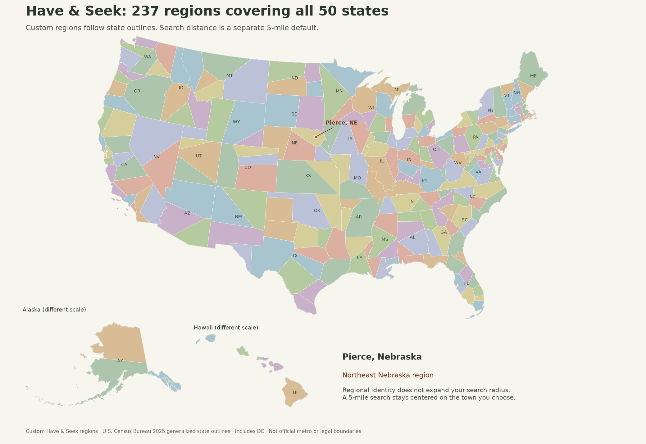
How Have & Seek's 237 named regions cover all 50 states and DC. Choose your location
Region boundaries are not search circles
- Regions (shown on the map below) name where a place is, for example Pierce, NE is in Northeast Nebraska. Every point inside each state's generalized mapped outline is in exactly one region of that state (towns just outside the simplified coastline use the closest region center in their own state).
- Searches are circles: by default 5 miles around the town or ZIP you choose, adjustable from 1 to 1,500 miles or all United States. A search can be smaller than its region or reach into neighboring regions and states. Choosing a region never limits or widens which posts match.
These are Have & Seek's own custom regions, used by the site to name your region; they are not official metro or county boundaries. Each state is divided by closest region center (measured in a map projection centered on that state) and clipped to the US Census Bureau 2025 cartographic state outlines (1:20,000,000), which are generalized: places on coasts and islands use the closest region center in their own state.
Exported map
Static image with Alaska and Hawaii insets, for offline viewing: current regions (237 regions, PNG). Data: regions (GeoJSON) · validation summary (JSON).
Coverage by state
| State | Regions | Covered (approx.) |
|---|---|---|
| Alabama | 4 | 100% |
| Alaska | 3 | 100% |
| Arizona | 3 | 100% |
| Arkansas | 3 | 100% |
| California | 16 | 100% |
| Colorado | 4 | 100% |
| Connecticut | 3 | 100% |
| Delaware | 2 | 100% |
| District of Columbia | 1 | 100% |
| Florida | 12 | 100% |
| Georgia | 6 | 100% |
| Hawaii | 4 | 100% |
| Idaho | 4 | 100% |
| Illinois | 5 | 100% |
| Indiana | 5 | 100% |
| Iowa | 4 | 100% |
| Kansas | 2 | 100% |
| Kentucky | 3 | 100% |
| Louisiana | 4 | 100% |
| Maine | 2 | 100% |
| Maryland | 4 | 100% |
| Massachusetts | 4 | 100% |
| Michigan | 8 | 100% |
| Minnesota | 4 | 100% |
| Mississippi | 4 | 100% |
| Missouri | 4 | 100% |
| Montana | 5 | 100% |
| Nebraska | 5 | 100% |
| Nevada | 2 | 100% |
| New Hampshire | 3 | 100% |
| New Jersey | 5 | 100% |
| New Mexico | 3 | 100% |
| New York | 9 | 100% |
| North Carolina | 6 | 100% |
| North Dakota | 4 | 100% |
| Ohio | 6 | 100% |
| Oklahoma | 2 | 100% |
| Oregon | 5 | 100% |
| Pennsylvania | 8 | 100% |
| Rhode Island | 1 | 100% |
| South Carolina | 4 | 100% |
| South Dakota | 2 | 100% |
| Tennessee | 5 | 100% |
| Texas | 13 | 100% |
| Utah | 4 | 100% |
| Vermont | 2 | 100% |
| Virginia | 7 | 100% |
| Washington | 6 | 100% |
| West Virginia | 4 | 100% |
| Wisconsin | 5 | 100% |
| Wyoming | 3 | 100% |
Approximate share of each state's generalized mapped outline (Census 2025, 1:20,000,000) inside one of its regions. Not a precise land-area measurement.